


2024_06_22_55 bornes

fredtruc27
User
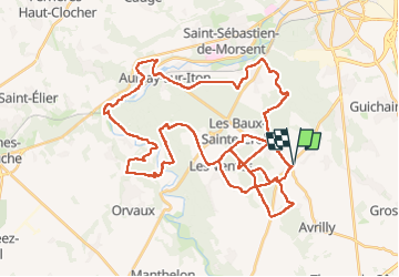

Length
55 km

Max alt
171 m

Uphill gradient
571 m
Km-Effort
63 km

Min alt
76 m

Downhill gradient
571 m
Boucle
Yes
Creation date :
2025-06-22 06:25:48.489
Updated on :
2025-06-22 10:21:15.082
3h39
Difficulty : Medium

FREE GPS app for hiking
 SityTrail
IGN / Geographical institutes
SityTrail Plus
The world is yours!
About
Trail Mountain bike of 55 km to be discovered at Normandy, Eure, Les Baux-Sainte-Croix. This trail is proposed by fredtruc27.
Positioning
Country:
France
Region :
Normandy
Department/Province :
Eure
Municipality :
Les Baux-Sainte-Croix
Location:
Unknown
Start:(Dec)
Start:(UTM)
362982 ; 5424250 (31U) N.
Comments